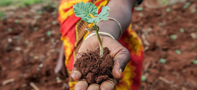
The more organic carbon there is in the soil, the healthier it is. Credit: Georgina Smith / CIAT.
On first arriving in Lushoto town, after winding up a steep mountain range, “diversity” is not the first word that comes to mind. Unless, that is, you know a lot about soil. Forming part of the Eastern Arc Mountains, which stretch between Tanzania and Kenya, this is a hotspot of biodiversity.
“What I’ve come to realize in my fieldwork over the last 10 years,” said CIAT soil scientist Leigh Winowiecki, “is that landscapes are extremely varied. Lushoto is a prime example. Carbon per kilogram of soil can vary between 15 and 150 grams within 10 kilometers,” she explains.
Soil health is measured through indicators, like organic carbon. Inherent soil properties like texture or structure, which have an impact on what crops can grow, where, and how well can be measured by the amount of organic carbon in the soil. The more organic carbon there is in the soil, the healthier it is.
The difference between 15 and 150 grams of carbon per kilogram of soil is, on one the hand, a reflection of the diversity of crops grown in the soil – from vegetables, beans, and cassava to trees. But it also shows that cultivation methods are reducing soil organic carbon and leading to soil erosion.
Digging up truth on dirt: new framework helps #soil researchers map the complexity of #Tanzania‘s landscape @CGIAR http://t.co/bazTXpizRU
— Georgina Smith (@georginajsmith) February 12, 2015
That’s what researchers call ground truthing. “It was actually believed that all the soil in Lushoto was one type,” she noted. “It turns out it’s more like four times that.” Soil analysis will enable researchers to build maps that not only reflect the true complexity of soils within the landscape but also put them in a position to give advice.
“Conventional scientific methods used to sample soils in varied landscapes are not adequate to capture the variability and assess the effects of land management,” said Winowiecki. “The Land Degradation Surveillance Framework we designed provides a biophysical baseline of soil and land health metrics across the landscape, so we can map variability better.”
In work with farmers to demonstrate the process of making soil profiles, soil samples were collected to determine soil properties in selected areas of the land. Samples were collected from 160 plots at two depths: 0-20 and 20-50 centimeters.
“Each soil sample we collected is linked to several other ecosystem health metrics,” said Winowiecki, such as erosion prevalence, tree densities, and current and historical land management strategies.
Scientists are now linking soil health data with household survey data on cropping diversity, perceptions of climate change, and gender together with socio-economic data to better understand and address farming system constraints.
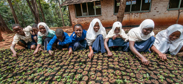
Strategic land management interventions like planting trees can improve soil health and overall agricultural productivity. Credit: Georgina Smith / CIAT
Using the framework, a biophysical baseline of key soil and land health information across the landscape can be developed to understand variability in soil types and effects of land use. A key purpose of the framework is to identify opportunities for strategic land management interventions that can improve soil health and overall agricultural productivity.
“If we can pinpoint what kind of soil farmers have on their farms, we can better advise about what crops to grow, and what types of inputs and management strategies would be appropriate,” said Winowiecki.
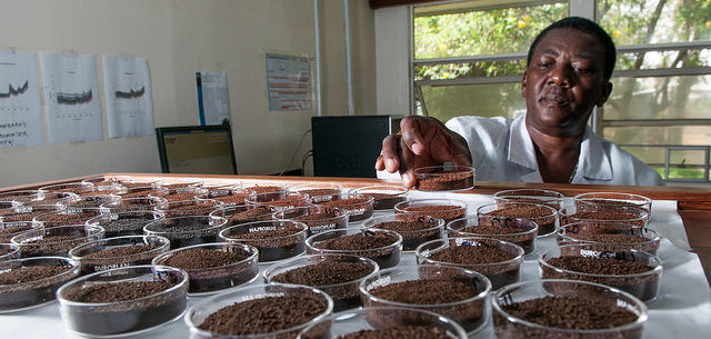
Based on soil analysis, local partners can advise farmers on soil fertility management. Credit: Georgina Smith / CIAT.
Identifying soil type and nutrient quantities, like nitrogen or exchangeable bases, which have an impact on plant growth, is combined with a more scientific approach to confirm results and build landscape maps.
Scholastica Morrison is a laboratory technician at the Selian Agricultural Research Institute (SARI), attached to CIAT. She disappears into an unassuming corner of her office and wheels in a trolley stacked full of petri dishes – colorful soil samples in every shade of brown.
The “magical robot” or near-infrared (NIR) spectrometer, as it is less affectionately known, is an advanced tool that is faster, cheaper – and just as accurate as previous techniques – for analyzing soil. Now, Morrison can scan 200-300 soil samples a day instead of just 20.
“The scans tell me about many nutrients required by the plant to grow – organic matter, nitrogen,” she said. By analyzing the samples, she can advise farmers what minerals are lacking in the soil, what fertilizer to use, and when or how much.
The new framework approach not only allows researchers to build data that better reflect the true diversity of soils in the Lushoto landscape. It also means farmers are more aware of what changes they need to make to reduce erosion and boost soil fertility on their farms.